NV Atlas Spain ES1 - Cabo San Antonio to Cabo Creus
Details
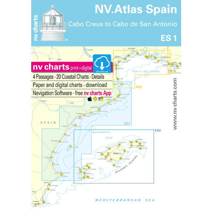
NV.Atlas Spain ES1 - Cabo Creus to Cabo San Antonio
Format: Kombipack Papier / Digital download and App
Passage charts
C1 Alicante to Rome 1: 1.750.000
C2 Cabo San Antonio to Peñiscola 1: 350.000
C3 Peñiscola to Barcelona 1: 350.000
C4 Barcelona to Cabo Creus 1: 350.000
District maps
C5 Cabo San Antonio to Cabo Cullera 1: 150.000
C6 Cabo Cullera to Cabo Canet 1: 150.000
C7 Cabo Canet to Cabo de Oropesa 1: 150.000
C8 Cabo de Oropesa to Pta. de la Baña 1: 150.000
C9 Pta. de la Baña to Cabo de Salou 1: 150.000
C10 Cabo de Salou to Barcelona 1: 150.000
C11 Barcelona to Cabo de Tossa 1: 150.000
C12 Cabo de Tossa to Cabo Creus 1: 150.000
C13 Cabo de la Nao to Olivia 1: 60.000
C14 Puerto de Olivia to Cabo Cullera 1: 60.000
C15 Valencia to Sagunto 1: 60.000
C16 Puerto de Burrina to Oropesa 1: 60.000
C17 Peñiscola to Pta. de Baña 1: 60.000
C18 Garraf to Barcelona 1: 60.000
C19 Barcelona to Mataró 1: 60.000
C20 Mataró to Blanes 1: 60.000
C21 Blanes to St. Felíu de Guíxols 1: 60.000
C22 St. Felíu de Guíxols to L’Estratit 1: 60.000
C23 L’Estratit to Cabo Creus 1: 60.000
Detailed maps
C24A Cadaqués · Portlligat 1: 15.000
C24B L‘Estartit · Isla Medas 1: 15.000
C24C Bahía de Roses 1: 15.000
C25A Puerto L‘Escala 1: 12.000
C25B Port d‘Aro 1: 17.000
C25C Palamós 1: 15.000
C25D St.Felíu de Guíxols 1: 17.000
C25E Blanes 1: 10.000
C25F Barcelona Olímpico 1: 15.000
C26A Arenys de Mar 1: 10.000
C26B Balís 1: 10.000
C26C Mataró 1: 10.000
C26D Premià de Mar 1: 6.000
C26E Badalona 1: 10.000
C26F Port Fòrum 1: 10.000
C26G Puerto Ginesta 1: 8.000
C26H Garraf 1: 7.000
C26I Aiguadolç 1: 7.000
C26J Vilanova i la Geltrú 1: 10.000
C26K Port Segur 1: 7.000
C26L Roda de Barà 1: 7.000
C27A Vinaròs 1: 10.000
C27B L‘Ametlla de Mar 1: 5.000
C27C Tarragona 1: 25.000
C27D Torredembarra 1: 7.000
C27E Cambrils 1: 8.000
C27F L‘Hospitalet de I‘Infante 1: 7.000
C27G Calafat 1: 5.000
C27H L‘Ampolla 1: 6.000
C27I El Masnou 1: 8.000
C28A El Grao 1: 25.000
C28B Puerto de Gandia 1: 10.000
C28C Valencia · America‘s Cup 1: 10.000
C28D Valencia · Yacht Hbr. 1: 10.000
C28E Puerto de Dénia 1: 15.000
C29A Farnals 1: 10.000
C29B Las Fuentes 1: 5.000
C29C-D Jávea · Benicarló 1: 10.000
C29E Burrina 1: 12.000
C29F Canet de Berenguer 1: 10.000
C29G Port Saplaya 1: 7.000
C29H San Carles de Ràpita 1: 12.000
C29I Puerto de Olivia 1: 10.000
C29J Islotes Columbretes 1: 60.000
Legend · General Notes p.30
Product information "NV Charts Spain ES1 - Cabo San Antonio to Cabo Creus"
With the NV Charts Spain Atlas ES1 you can discover the Spanish Mediterranean coast from Cabo San Antonio to (almost) the French border. Thanks to the clear layout, recreational boaters can quickly find approaches, harbours and anchorages and are informed of navigationally important details that also appear in the NV Charts app. The chart series impresses with its optimal dimensions and balanced sheet sections.
Regions overview
The ES1 starts at Cabo de San Antonio, known in Valencian as Cap de Sant Antoni. Whales and dolphins have already been spotted at this cape near Denia, which is located to the north of Alicante. Denia has a number of yacht harbours and marinas, as it is the shortest route from the Balearic Islands to the mainland. After rounding the cape, the route leads directly to the city of Valencia via the Gulf of Valencia on the coast. This is definitely worth a stopover, as it is known for its mix of modern and historic buildings, among other things. There are countless beaches and many well-equipped marinas to the north of Valencia.
An insider tip is the Ebro Delta, which is still relatively little frequented by tourists. From there, it is not far to Barcelona. The unique architecture and culture of Catalonia should not be missed in the capital. The rest of Catalonia's coastline stretches from Barcelona to the French border. Predominantly rocky and mountainous in the Pyrenees, the coast is characterised by numerous bays, the calas, which often end in shallow sandy beaches. Lots of vegetation and pine forests provide colourful accents. Costa del Garraf, Costa del Maresme and the wild coast of the province of Girona - the Costa Brava - are the names of the coastal stretches that accompany you northwards to the French border. On a peninsula that juts out 10 kilometres into the Mediterranean lies the most eastern point of the Iberian Peninsula - Cap de Creus. This natural park is well worth a visit.
We recommend the ES2, which will take you to the Balearic Islands, or the FR9, which will take you along the French coast towards the Cote d'Azur. However, if you then want to head towards Gibraltar, the ES3 is the perfect travelling companion. We also have suitable door guides for all these regions, which we will be happy to advise you on.
This set of cards includes
- 4 passage charts
- 19 territory maps
- 45 detailed maps
- Digital charts for navigation program and NV Charts App 356-day licence
- Navigation instructions in English
- Harbour plans paper & digital
- Fulfils all legal requirements for up-to-date paper charts on board
More Information
| Area | Spain |
|---|---|
| Supplier ref | 1502 |
| EAN code manufacturer | 9783910644472 |
| Brand | NV Charts |
| Medium | Paper |
| Product weight (kg) | 2.0000 |