Nautical charts
Detailed maps specially designed for navigation at sea. They show water depths, coastlines, buoys, beacons, and other important information for safe navigation.
Explore a comprehensive collection of charts and maps to navigate the seas with precision and safety. Whether you're a seasoned sailor or a novice boater, discover detailed nautical charts tailored to your region, providing essential information on depths, currents, landmarks, and navigation aids. From the coasts to offshore passages, find the right chart to plan your voyages and explore the waters with confidence
Shop By
 Imray C34 Cap d'Erquy to Ile de BatzSpecial Price €34.98 Regular Price €37.63
 Imray C35 Baie de Morlaix to L'Aber-IldutSpecial Price €34.98 Regular Price €37.63
 Imray C36 Île d'Ouessant to Raz de SeinSpecial Price €34.98 Regular Price €37.63
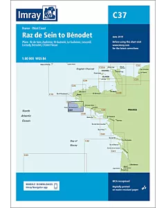 Imray C37 Raz de Sein to BénodetSpecial Price €34.98 Regular Price €37.63
 Imray C38 Anse de Bénodet to Presqu'île de QuiberonSpecial Price €34.98 Regular Price €37.63
 Imray C39 Lorient to Le CroisicSpecial Price €34.98 Regular Price €37.63
 Imray C40 Le Croisic to Les Sables d'OlonneSpecial Price €34.98 Regular Price €37.63
 Imray C41 Les Sables d'Olonne to La GirondeSpecial Price €34.98 Regular Price €37.63
 Imray C42 La Rochelle to SantanderSpecial Price €34.98 Regular Price €37.63