Nautical charts
Detailed maps specially designed for navigation at sea. They show water depths, coastlines, buoys, beacons, and other important information for safe navigation.
Explore a comprehensive collection of charts and maps to navigate the seas with precision and safety. Whether you're a seasoned sailor or a novice boater, discover detailed nautical charts tailored to your region, providing essential information on depths, currents, landmarks, and navigation aids. From the coasts to offshore passages, find the right chart to plan your voyages and explore the waters with confidence
Shop By
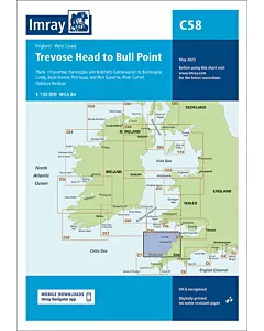 Imray C58 Trevose Head to Bull PointSpecial Price €34.98 Regular Price €37.63
 Imray C59 Bristol ChannelSpecial Price €34.98 Regular Price €37.63
 Imray C60 Gower Peninsula to CardiganSpecial Price €34.98 Regular Price €37.63
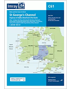 Imray C61 St George's ChannelSpecial Price €34.98 Regular Price €37.63
 Imray C62 Irish SeaSpecial Price €34.98 Regular Price €37.63
 Imray C63 Firth of ClydeSpecial Price €34.98 Regular Price €37.63
 Imray C64 Belfast Lough to Lough Foyle and CrinanSpecial Price €34.98 Regular Price €37.63
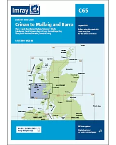 Imray C65 Crinan to Mallaig and BarraSpecial Price €34.98 Regular Price €37.63
 Imray C66 Mallaig to Rudha Reidh and Outer HebridesSpecial Price €34.98 Regular Price €37.63
 Imray C67 North Minch & Isle of LewisSpecial Price €34.98 Regular Price €37.63
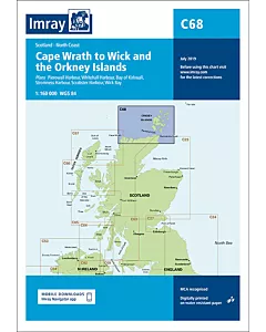 Imray C68 Cape Wrath to Wick and the Orkney IslandsSpecial Price €34.98 Regular Price €37.63
 Imray C69 Belfast to Strangford LoughSpecial Price €34.98 Regular Price €37.63
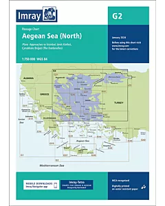 Imray G2 Aegean Sea (North)€28.47
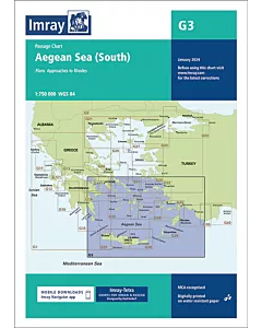 Imray G3 Aegean Sea (South)€28.47
 Imray Y9 The WashSpecial Price €22.26 Regular Price €23.43
 Imray Y16 Walton Backwaters to Ipswich and WoodbridgeSpecial Price €22.26 Regular Price €23.43
 Y17A The Rivers Colne and BlackwaterSpecial Price €25.41 Regular Price €26.74
 Imray Y18 The River Medway and Approaches Sheerness to Rochester and River Thames Sea ReachSpecial Price €22.26 Regular Price €23.43